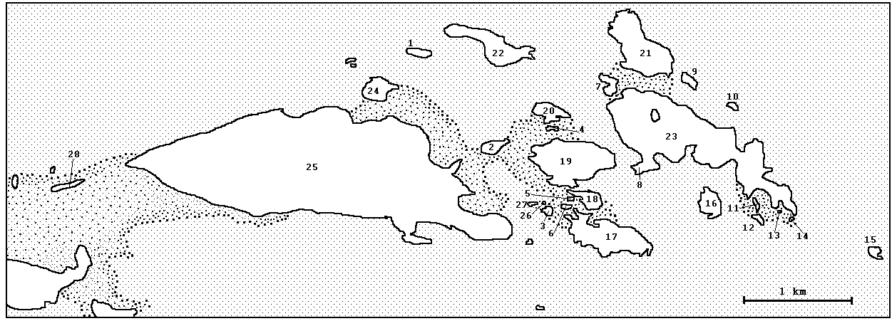
The shcheme of the Kemj-Ludskiyj archipelago according to the data of 2003
The materials of the White sea expedition
[Islands' photos]
[The map of the Kemj-Ludskij archipelago
by N.V. Vekhov]
Legend:
The sea is marked by dark-grey, the litoral is marked by points. The
islands' names, which were given by the members of the White sea expedition are
marked by *. The islands' numbers according V.N. Vekhov and alternative names are given in brackets.
[Russian names]
1 -- Korablik* (luda №1, Ploskaya Luda)
2 -- Materinskaya Luda* (luda №2, Korzhnichikha Malaya)
3 -- ZHguchiyj* (luda №3)
4 -- Sinopchikha* (luda №4, Malaya Luda)
5 -- Nakhadu* (luda №5)
6 -- Matrasik* (luda №6)
7 -- Rogalik* (luda №7, Asaf'ev Perejma)
8 -- Trubnaya Luda* (luda №8, Otprysk, now is a peninsula)
9 -- Alpiyjskaya Luda* (luda №9, Asaf'eva I, Malyj Asafij; doesn't connect with B. Asafjev in the low
water)
10 -- Pisanaya Luda* (luda №10, Asaf'eva II)
11 -- Ot Vinta* (luda №11)
12 -- Verkhnyaya Luda* (luda №12)
13 -- Novaya Luda* (wasn't marked by V.N. Vekhov)
14 -- Tozhe Luda* (wasn't marked by V.N. Vekhov)
15 -- Grumand
16 -- Gusinihyj
17 -- Zelenihyj
18 -- Sredniyj
19 -- Izbyanoyj
20 -- Sovinihyj
21 -- Malijyj Asafjev (Asaf'eva Perejma)
22 -- Korzhnichikha (Korzhnichikha Bol'shaya)
23 -- Boljshoyj Asafjev (Asafij)
24 -- Pereyjma
25 -- Kemj-Ludskiyj
26 -- Tinki* (wasn't marked by V.N. Vekhov)
27 -- Vinki* (wasn't marked by V.N. Vekhov)
28 -- Dolgaya Pribrezhnaya
To the main page